Wednesday, July 30, 2008
Mountians, Alpine Tundras, Lakes and Waterfalls
Joe and Ned on a Rocky Mountain High
We had a long full day today. We started off the morning with a talk on the park's bighorn sheep. We learned about how their horns grow and why they come down from the mountains to places like Sheep Lake (it is the minerals in the mud.) After the talk we had an early lunch at the Endovalley Picnic area next to the Fall River before heading up the Old Fall River Road.
The Old Fall River Road was the first road in Rocky Mountain National Park to the park's high country. It was eventually replaced by the Trail Ridge Road and on the park's website they call the Old Fall River Road a "motor nature trail." The road was completed in 1921 and it is narrow and can be a bit steep in parts. It is 11 miles long, gravel, one-way uphill and has many switchbacks. It is not a hurry along road but a slower paced, relax and savor the experience road. It ends at Fall River Pass, 11,796 feet, near the Alpine Visitors Center.
Near the start we passed the alluvial fan scoured out by the 1982 Lawn Lake Flood which flooded part of the park and even the town of Estes Park. We stopped at Chasm Falls and hiked along the river to the spot where it plunged over the rocks and into a chasm. It was a beautiful morning and the rest of the drive was spent just enjoying the views.
When we reached the Alpine Visitor Center we hiked the Alpine Ridge Trail. It leads to the summit of a mountain near the visitor center. It was brisk and windy at the top and we were glad we wore our jackets. We had a quick snack at the visitor center before continuing along Trail Ridge Road. There were some places we wanted to see that we missed on the way into the park. One was at Rock Cut to hike the Tundra Communities Trail. It is just a quick hike through the alpine tundra and at the end there are some great rocks to climb. While the boys climbed I had a conversation with a couple from Rapid City, SD. Mentioning we were head for the Black Hills they told me that it was the start of Sturgis, a huge week long motorcycle rally and I should make sure we had a place to stay.
We also stopped at some overlooks like Many Parks Curve. At Hidden Valley the site of an old ski resort we worked on finishing our Junior Ranger books. When we got to the Beaver Meadows Visitor Center all three of us were able to receive Junior Ranger Badges. Then we drove to Bear Lake a beautiful alpine lake at the base of Hallett Peak and Flattop Mountain. One of Rocky Mountain National Park's most famous and popular trails is the Bear Lake Trail. It combines views of the mountains, the Bear Lake and a short walk, a 0.6 mile loop. It had started to rain a bit when we arrived but didn't last long. Just down the road a bit is the Glacier Gorge Trailhead where we hiked a little under a half mile to Alberta Falls. Glacier Creek thunders down this waterfall which is another of the park's more popular hiking destinations. Since we were there so late in the day we were pretty much alone. It also meant that we couldn't visit some of the other lakes in the area. There were hungry boys to feed.
We returned to the campsite pretty tired and hungry. We got a campfire going and sat around it eating our ramen noodle dinner. Tomorrow we are leaving this beautiful park and going to Denver.
The Bighorn Sheep Ranger Talk
Hiking to Chasm Falls
The Way Up the Alpine Ridge Trail
The Never Summer Mountains
The Trail Ridge Road
Longs Peak
Looking East Along Horseshoe Park
The View From Our Campsite
Picturesque Bear Lake
Joe and Ned at Alberta Falls
Labels:
2008,
Colorado,
hiking,
Junior Ranger,
National Park,
road trip,
summer,
vacation
Tuesday, July 29, 2008
A Beautiful Drive
Joe and Ned in the Snow in July
We were up and broke camp in good time this morning. We were headed for Rocky Mountain National Park in Colorado. We had reservations at a campground in the park so we were not pressed for time. From Moab, UT we turned onto Utah Route 128, the Upper Colorado Scenic Byway, and followed the Colorado River north. The river here has cut a wide canyon and the red rock walls in the early morning light are beautiful.
Soon we were on Interstate 70 and back in Colorado. We stopped in Grand Junction, CO to see an eye doctor. The piece of contact was still in my eye and really bothering me. After successfully having it extracted by the very helpful Melinda Hicks OD we explored downtown and had breakfast at a bagel shop.
I70 through the mountains of Colorado is a beautiful drive especially through the Glenwood canyon. The highway flows with the Colorado River. The lanes pass over and under each other and at times you are alone as the other lane pierces the mountain through a tunnel. Along the highway there is a multi-use trail that weaves in and out of the highway and river. We made a quick stop at Vail for gas. We passed through the Eisenhower Tunnel built under the Continental Divide at an elevation of 11,158 feet, the highest tunnel in the US. It is also the longest tunnel in the Interstate highway system, 1.7 miles.
Leaving the interstate we turned north onto US Route 40. We had a pleasant lunch in Empire, CO and then drove up Clear Creek Canyon and over Berthoud Pass, 11,307 feet, and back across the Continental Divide. This was another beautiful drive with fantastic views.
We entered Rocky Mountain National Park at the south entrance and stopped at the Kawuneeche Visitor Center. We picked up Junior Ranger books for all of us and checked out what to see in the western part of the park. We were now on Trail Ridge Road the highest continuous paved road in the nation.
Our first stop was a quick hike on the Coyote Valley Trail through the Kawuneeche, Arapaho for coyote, Valley. Sometimes elk and moose are sighted but all we saw were some fish in the river. If we thought the Colorado River was cold at Lee's Ferry it was even colder here so close to its origin.
Our next stop was Lake Irene, a pretty little alpine lake. It started to lightly rain as we parked so we took a quick walk around part of the lake. As we were returning to the car we saw a pine marten which is a pretty rare sight. Next was Milner Pass, 10,758 feet, where Trail Ridge Road crosses the Continental Divide. We took a short hike to stand in a bit of remaining snow pack nearby. On a ridge overhead there were bighorn sheep and a man walking back from the snow said there was beaver. It was a marmot sitting on a rock eating some grass. While we slipped and played in the snow we realized we were not alone. A small herd of bighorn sheep had walked right up to us. As we watched them they climbed up the steep hillside and joined the others on the ridge. As we walked back to the car we saw a herd of elk lying down near a small pond.
At Medicine Bow Curve we took a quick alpine hike to look at wildflowers. We startled a ptarmigan as walked by some bushes. The Alpine Visitor Center was closed but we saw more elk and a big marmot on the a wall. A German visitor showed me a hole in his pants where a marmot walk up and bit it. He was so happy. The Rock Cut overlook had a bunch of pikas and a family of marmots running around. As we approached the campground we came across a group of mule deer in the woods.
We had camp set up in time to attend the campground ranger program on Our National Parks. We learned that there are 29 different types of park units from parks, monument, memorials, historic parks, to lake shores.
Driving Along the Upper Colorado Scenic Byway
Cows on Board Get Free Soup
After This Stretch, No More Red Rocks
Kawuneeche Valley
Joe Checks the Water Temperature While Ned Throws Rocks
Kawuneeche Valley From Fairview Curve
Some of the Bighorn Sheep That Visited Us
Joe is Going East and Ned is Going West
Cache la Poudre River Valley From Medicine Bow Curve
Mountain Flox Still Blooming in the Alpine Tundra
The Lone Marmot
Moab, UT to Rocky Mountain National Park Moraine Campground, CO, 419 miles 9 hrs 58 min
Labels:
2008,
Colorado,
hiking,
Junior Ranger,
National Park,
road trip,
summer,
Utah,
vacation
Monday, July 28, 2008
Arches National Park in the Sun
Joe and Ned Standing Beneath Wall Arch
It rained again last night but by morning it was dry. It is the monsoon season. We started off the day hiking the 7.2 mile Devils Garden Trail including the Primitive Loop. There are nine arches to visit including Landscape Arch. We started off a bit late and arrived at the trailhead around 9:30 am.
There are short spurs to Pine Tree Arch and Tunnel Arch almost right away. Then after about three quarters of a mile is Landscape Arch. For most visitors Landscape Arch is the high point of the Devils Garden. It is a slender ribbon of stone 290 feet long and 105 feet above the desert floor. Landscape Arch is probably in the last stages of its existence. In 1991 a 60 foot section dropped from the arch making it thinner. The trail continues northward past Wall Arch a very accessible arch. Then a short spur leads to Navajo and Partition Arches. Partition Arch is two large holes in the rock face. The main trail ends at Double O Arch a little over two miles from the trailhead.
To return to the trailhead you can retrace your steps or you can turn north from Double O Arch, and take the loop trail that goes back through Fin Canyon. This trail is what the Park Service calls a "primitive trail." It is not as well developed as the main Devils Garden Trail, but it is quite easy to follow. The trail wanders through thin stone fins that were formed millions of years ago when the ground rose beneath a solid block of sandstone, causing it to fracture and separate into long, parallel vertical sheets. These fins are the primary reason why so many arches have been formed in Arches National Park. Private Arch is an especially beautiful arch and lives up to its name because you are usually the lone visitor.
After spending about a mile in the fins the trail breaks out on the eastern side of Devils Garden and into a wide wash. At this point I realized I was in trouble. With the lack of shade my body quickly becoming dehydrated. On top of that this is where I ran out of water. As we hiked on I got worse. I had to get to the main trail if I wanted to walk out of the park and not be carried. Once we got there I managed about another half mile until we came to a large hill which I didn't think I could climb. I found a shady spot in the rocks and sent Joe to find a ranger for help.
After about fifteen minutes Joe returned with some water bottles. He had told a group of people that I needed help and they gave him their water and went to find a ranger. The water was just what I needed. After drinking both bottles I decided to try for the parking lot and the water spigot there. As I stepped out on the trail I wondered where the hill was and Ned said that we had already gone over it. I had been really out of it. On the way to the parking lot a park worker gave me more water and walked with me. After sitting and drinking more water at the parking lot I felt much better.
We drove to the visitor center where the boys finished their Junior Ranger booklets and received their badges. We went back to the campground and hung out at the pool for a couple of hours. I drank lots of water. After showering one of my contacts stuck in my eye. I couldn't get it all out. We went to the Moab Diner for dinner and then the coolness of the library for the rest of the evening. By the time we went to bed I felt much better though my shirt will probably never be the same.
It was an experience that I will try to avoid repeating. We should have started a little earlier and taken more water. It was amazing how bad I felt in such a small amount of time. On the way out we passed some hikers going out on the trail and most of them didn't have water. I tried to warn them.
Pine Tree Arch, Ned Standing in the Bottom Middle
Landscape Arch is 290 Feet Long
The Devils Garden Trail Follows the Fins
Ned and Joe Sitting Partition Arch
Joe Checks Out the Neat Rock Formations
Ned Found a Nice Little Hole
Looking Into Fin Canyon
Double O Arch
Joe Trekking Through Private Arch
The Devils Garden Trail
Labels:
2008,
hiking,
Junior Ranger,
National Park,
road trip,
summer,
Utah,
vacation
Sunday, July 27, 2008
San Jaun Skyway to Arches
Joe on the Run Through Molas Pass 10,910 Feet
The rain started again in the night and we awoke to find that the tent had leaked. It seeped up through the floor and there was a spot near the door that had formed a puddle. We quickly broke camp and packed a wet tent hoping that we would be able to dry it out at tonight's stop.
Soon after leaving Mesa Verde we stopped in Durango, CO to have breakfast. As we pulled into town we were greeted by the 8:15 am Durango & Silverton Narrow Gauge Railroad leaving town for Silverton. The D&SNGR is now an excursion train that runs coal-fired, steam powered locomotives on the same tracks miners and ore used over a century ago. As we waited for the train to pass the crossing we waved hello at the passengers. Breakfast was at the Durango Diner. They have huge pancakes and a good green chili. I had the biscuits and gravy and green chili. Pretty tasty. The one disappointment was the cinnamon roll we ordered. It was really dry.
From Durango we headed north onto Colorado 550 also known as the Million Dollar Highway and part of the San Juan Skyway. The route through the mountains has three passes over 10,000 feet and is one of the most beautiful drives I have taken. The weather was perfect which made it even more splendid. Water in snowmelt streams cascaded down the sides of the mountains and wildflowers added bursts of color. We stopped at one spot to wade in a stream but the water was near freezing. As we headed north we passed through a number of small towns and even some ghost towns. This area was booming in the late nineteenth century and towns came and went with the fortunes of the mines.
Once we reached Ridgeway, CO we turned west and into Utah. As we left the mountains we returned to the brown and red rock of the Colorado Plateau. Soon we were in Moab, UT and then Arches National Park.
The Durango & Silverton Narrow Gauge Railroad
The Durango & Silverton Narrow Gauge Railroad Movie
Mountain Wildflowers
Whipple Penstemon Blooms Near a Snowmelt Fed Stream
Tunnel on the Skyway
The Idorado Mine Near Silverton, CO
The View Along the Million Dollar Highway
Utah is Straight Ahead
When we reached Arches National Park we were disappointed to find the campground was full. So we turned back to Moab and found a campsite at Canyonlands Campground. We set up some clotheslines and hung the tent up to dry. While the tent dried we drove back to Arches to do a little exploring since it was still fairly early in the afternoon.
Arches National Park was created in 1929 as a National Monument to protect and preserve the over 2,400 natural sandstone arches, like the world-famous Delicate Arch, as well as many other unusual rock formations. In 1971 congress changed its status to National Park. As you drive into the park you begin to see the extraordinary features that are part of a landscape of contrasting colors, landforms and textures that is unlike any other I have seen in the world.
On the road we passed many rock formations like the Three Gossips and the Organ. A landscape of petrified dunes flowed off to the right and the Great Wall made a barrier on the left. We drove past Balanced Rock and then to the parking lot for the Delicate Arch Overlook. We hiked to the upper overlook and arrived near sunset. It was wild being on the sliprock as the sun was setting and the wind whistled around us. At the end of the trail we looked out over a canyon to Delicate Arch on the other side. Unlike the Grand Canyon, or perhaps because of our recent visit there, the landscape was more accessible, more human. It didn't feel that you would get lost in it.
Since it was late we returned to Moab and had dinner. The tent was all dried out when we returned to camp so we set it up and went to sleep.
The Three Gossips and Sheep Rock
Balanced Rock
Delicate Arch at Sunset From the Overlook
Balanced Rock Looks Like the Thumb to a Giant Hand
Mesa Verde National Park, CO to Arches National Park, UT, 241 miles 5 hrs 40 min
Saturday, July 26, 2008
Exploring the Dwellings of the Ancients
Joe and Ned Enter the Kiva at Spruce Tree House
Mesa Verde National Park was established in 1906 by President Theodore Roosevelt to "preserve the works of man," the first national park to do so. The Ancestral Pueblo people made it their home for over 700 years, from A.D. 600 to A.D. 1300. There are over 4,000 known archaeological sites, including 600 cliff dwellings.
Friday morning we were up and ready for our first cliff dwelling tour, 9:00 am tour at Cliff Palace. After a quick breakfast we drove through the park to Chapin Mesa. Cliff Palace is the largest cliff dwelling in the park. Ninety percent of the cliff dwellings contain 10 rooms or less and one-third have one or two rooms. This means that the more famous cliff dwellings like Cliff Palace (150 rooms), Balcony House (40 rooms), and Long House (150 rooms) are the exception. We started at the Cliff Palace Overlook with a talk by a ranger. Since the tour is considered strenuous because of the five ladders and 100 foot elevation change the rangers want to make sure that you can make it and if you feel like you cannot, turn back now.
The dwelling itself is amazing. We were the first tour so there was no one else in the dwelling. The quiet of the canyon made the emptiness of the alcove more apparent. We learned about the differing theories on why the ancient peoples moved to the cliff alcoves from their mesa top homes and why they left Mesa Verde. Most likely the answer to both questions is resource depletion. While we were on the tour a boy about Joe's age passed out. It was pretty shocking but he was okay. He hadn't eaten breakfast.
After Cliff Palace we toured Balcony House. Balcony House is labeled as an Adventurous Cliff Dwelling Tour by the park. To enter the dwelling you climb a 32 foot ladder and to exit crawl through a 12 foot long tunnel and climb up a 60 foot open rock face with two 10 foot ladders. At least we didn't have to go the way the original inhabitants used, small hand and foot holds chipped into the cliff face. An interesting fact we learned was that bodies found with broken bones were very few and they were of the old. Balcony House is named for the balconies that were built on the outside of the houses.
After the tour we did a short hike on the Soda Canyon Overlook Trail. This leads to an overlook for a view of Balcony House. We were pretty hungry by now so we dropped into Spruce Tree Terrace for lunch. After lunch we walked down to Spruce Tree House which is the best preserved of the cliff dwellings and even has some parts restored. The boys climbed down into a kiva to see what it was like. We then visited the Chapin Mesa Museum. It has dioramas of Ancestral Puebloan life and exhibits of prehistoric artifacts of Ancestral Puebloan culture. While visiting the museum the boys received their Junior Ranger badges.
Driving along the Mesa Top Loop we made a few stops to see earlier pit houses where the Ancestral Puebloans lived before moving to the cliff dwellings. Then we headed out of the park to Cortez. On the way we stopped at Park Point Overlook the highest point in the park at 8572 ft with a 360 degree view of the surrounding countryside.
We were going to go to the library but it was closed so we stopped at the grocery store for dinner supplies and then back to the park. It started to rain but stopped after a half hour. Later we went to the campground ranger program on the history of the Civilian Conservation Corps and their work in Mesa Verde National Park and then to bed.
The Park Entrance When it Wasn't Raining
Cliff Palace
Ned and Joe Look Over Cliff Palace
Ned Knows the Answer
Joe Reviews Balcony House Before Our Tour
The Big Ladder From the Bottom
Climbing the Big Ladder to Balcony House
The Tunnel Out of Balcony House
Joe and Ned Climb Up the Cliff
Balcony House From the Soda Canyon Overlook
Square Tower House is the Tallest in the Park
Spruce Tree House from the Park Superintendent's Porch
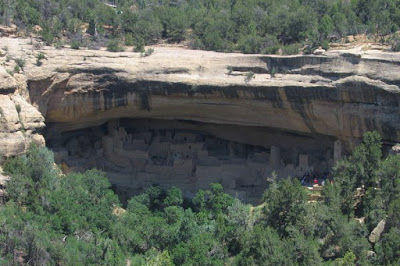
This morning started with a tour of Long House on Wetherhill Mesa. It is a 12 mile drive to the parking area where a tram takes you to the start of the tour. But first the rangers went through their warning speech about climbing, falling, staying on the trail and not touching anything. Long House is the second largest cliff dwelling in Mesa Verde. One interesting feature of Long House is the Great Kiva, an open air kiva like those of Chaco Canyon. Archaeologists believe this is a sign that some of the people from Chaco Canyon came here after their culture collapsed. There are only two 15 foot ladders to climb at Long House making it a nice walk.
After the tour we headed into Cortez and spent some time at the library. We had dinner at Let it Grow a garden center that has a small cafe inside. Our dinner was very good. As we headed back to the park the skies began to darken and it began to pour. As we passed through the park entrance it turned to hail. I worried about our tent but as we came to a bend in the road I was more worried about if we were going to be able to continue farther into the park. The heavy rain was washing the hillside onto the road and there were large rocks scattered across the road. We got through and back to camp.
The tent was okay and fortunately the rain had slowed quite a bit. We went to the campground center to take showers and do laundry. There were a lot of people there and I found out that the park was closed because of the rocks on the road. I am glad we got in though I was worried that we couldn't leave in the morning. It was funny in a way all of the rain we had at Mesa Verde. Normally they only get about 15 inches a year. I think most of that fell in the three days we were there. Once the laundry was done we went back to our campsite and did some reading. Tomorrow we were headed for Arches National Park in Utah and I wanted an early start.
Long House
A Hand Print on the Alcove Ceiling
Long House From the Other Side
Ned Waits for the Tour to End
Labels:
2008,
Colorado,
hiking,
Junior Ranger,
museums,
National Park,
road trip,
summer,
vacation
Subscribe to:
Posts (Atom)